Amazing Alignment of thousands of shallow Band of Holes

Amazing Alignment of thousands of shallow Band of Holes

In the valley of Peru Pesco,  there is a strange arrangement of cursory and superficial pits. The pits are aligned in a narrow band and their width is around 14 to 20 meters, which meets up a hill for about 1500 meters. Their function or purpose is a mystery. The specialty is that it is famous as Cerro Viruela (Smallpox hill) or Monte Sierpe (Serpent mountain). It is also known as the name Band of Holes.

Cerro Viruela is a well-known site, it is also famous among archeologists who have been doing work in Peru for many decades.

This site first became famous among visitors in the 1930s due to an aerial Photograph of aviator Robert Shippee which he published in National Geographic. After that, a little number of archeologists went there to see the site. In 1953, another person who was American visited Victor Wolfgang von Hagen explored the area, and explained the pits as graves, he said that those are like empty graves. He described that there are almost 5,000 such graves on the site.

John Hyslop also an archeologist, wrote in his book titled The Inka Road System that such type of circular structure can be used for storage, similar to the ones found on the coast of south Peruvian in the sites Quebrada de la Vaca and at Tambo Colorado.

The width of the holes is almost three feet across and their length is 20 to 40 inches deep. There are available there with different types, some of it was artificial mounds of mud and the others were made up of small rock structures on the earth. The band consisted of many different patterns of holes.

Amazing Alignment of thousands of shallow Band of Holes

Satellite view of Band of Holes.
A team of archeologists from the University of California visited in 2015, explored it, and made a comprehensive study of the site, they created a mao of the Band of Holes by using a drone, and they explained after the analysis that it is mad up between 5,000 and 6,000 depressions.  These archeologists did not get any solid evidence, but a road named Inca was found nearby, many numbers of colas (Inca-period storage houses), and they discovered the Inca-period pottery near the band, it concludes that the Band of Holes dates to sometime around the fifteenth century after the Inca Empire defeated the people of Chincha. They also noticed the holes were just used for the one time to store something, but they were confused that why was not clear.

Another researcher from the University of California, Charles Stanish, who was an expert on Andean cultures and explored it. And described that these holes were made to measure products that farmers used to deliver to the Inca kings as tributes.The Band of Holes is located in the beautiful valley which is agriculturally produced and named Pisco Valey, this is just four miles away from Tombo Colorado, which is a massive 15th Century Inca Administrative center. The Band of Holes is made along a road that is leading from the floor of the valley to Tambo Colorado. According to Stanish, “It’s the perfect place to stop, measure your produce, and make sure you have the proper amount of tribute,”. He thought that each block of the holes belonged to a different family, or ayllu, that relates to a different tax-paying group. He said you should have each social group come up and then fill up their holes with maize, squash, or any other product in front of the accountants of the state. These goods can be shifted to Tambo Colorado, or wherever the authorities wanted to take them.

In the end, after the conclusion of many studies, no one knows where these holes come from.

Amazing Alignment of thousands of shallow Band of Holes

Photo: Paul Catacora

The Mystery of Vanishing three Lighthouse Keepers of Flannan

The Mystery of Vanishing three Lighthouse Keepers of Flannan

The lighthouse on Flannan Isles. Photo: XopherD/Flickr 

The incident of three men who disappeared off an island which is remote in the Outer Hebrides. There were cold days in December of 1900. They left no trail or trace, save the portion of unusual sights such as dinner that was untouched, an oilskin that was there in the stormy wind of the Atlantic, and a book with the recordings of all the strange things which were happening. Those people were the guardian of the lighthouse of Eleanor Mor. Almost one century has passed but no one knows how these three men disappeared.

It started in 1895, the lighthouse Flannan Isles was built atop a 150 feet high cliff- that was the first thing used to light up the heavy seas around the island. The area was less populated, the four men were there to manage the station and as guards who watch everything for the tower. There were Thomas Marshal, James Ducat, Joseph Moore, and Donald MacArthur. Of four men usually, one man used to take weekly leave on a rational base the other always stayed at the lighthouses. 

Everything is going well, and daily they achieved many things and that was the great things happening there and they found that there is no light in the sky to show their success there One ship noticed when it was passing from there. This boat is called Hesperus and came to the Island to deliver supplies and the 4th guard who was on leave named Joseph Moore. So, the team was met with a strange environment and they felt that something is not right there because of its emptiness. There was no guard for protection and no feeling that they were going to welcome from the lighthouse.  

The missing lighthouse keepers. Photo colourized by Grant Kemp.

The needles of the clock were stuck and many signs appeared that this incident must have happened before a week. It was the telegram of a Captain who belongs to Hesperus.

In this lighthouse, A clean oil lamp was found by Moore that was ready for lightening, but this was not used for days. A table was also found there, some eatables were on it and it seemed that it was never eaten. 

For investigating what happened there, take a closer look at the situation, people who went there observed that something had been prepared for days on that island. They looked on to the log book that was maintained by guards in which they found some strange entries. Marshal said that the island had been under pressure from an extreme storm that is much different from other.

He had also recorded that during the time McArthur and Ducat were showing some unusual behaviors, the situation of McArther was very pitied he had been crying. On the other hand, Ducat’s behavior was serious and he had been quiet. The storm that had ended on 15 December was found in the entry book and it was its final entry of 9 am.

To find the answer to this mystery, and how it all happened they need to be focused. This disappearance happened on 15 December which could be possible during the day. In those people, one man Moore soon starts to scan the environment. The gear and ropes on the East landing were complete. So, there was no hint of their disappearance across the island. They found no evidence that those poor men had lost their lives.

Robert Muirhead investigated the case of this island and concluded that the lifeboats of this island had disappeared. After a hundred and twenty years, there is the same question still alive and nobody could find the answer.
References:
# Mental Floss
# The Vanishing Lighthousemen of Eilean Mor
# Vice
# Web Archive
# Pan Macmillan

West African Lungfish, that Lives on Land

West African Lungfish, that Lives on Land

A lung fish in its cocoon lying outside its burrow. Photo credit: Scrubhiker (USCdyer)/Flickr

The lungfish is the kind of that vertebrate that can be found in freshwater. One of the best
lungfish is Dipnoj and it is famous for retaining ancestral characteristics in the Osteichthyes, it
can live on the land, it can live without water for a long time and mostly she can live without
water even years. This name is suggested due to its ability to take oxygen directly from the air
because it has a huge respiratory system. It is just like a land animal because, in most species of
fish, it can’t stay on land, and also not possible to live without water. Most of them in such
species do not use their gills, as we know that if we do not use a part of our body, it can be
useless. In the same case, these species of lungfish always take a breath in the air and they lost
the function of their gills when these fishes become adults. These fish are very used to the land, it
is also possible for them to drown if they stayed underwater for a long time. It has well
developed internal skeleton because there are lobed fins present in its body. This fish is the
closest relative of the tetrapod. Nowadays there are six species available that are living on
different continents such as South America, Africa, and Australia. The record of fossils shows
that there was a huge quantity of lungfish species since the Triassic. On the other hand, the
suggestion of the vicariance represents an old distribution that was limited to the
Mesozoic supercontinent Gondwana, the record of fossil suggest that there was a widespread
distribution of the freshwater, and its current distribution which is modern lungfish species
shows the image of extinction of many lineages after the breakup of Pangaea, Laurasia, and
Gondwana. The history of lungfish is referred to as salamanderfish, but most of the time this
term relates to  Lepidogalaxias.

The lungfish have long bodies same as eels, and there is a thread just like pectoral and pelvic
fins, that they use to crawl and swim along the bottom. They inhabit fewer deep waters, such as
marshes and swamps, but they are mostly found in bigger lakes.
The behavior of the lungfish is just like the other fish when they are in the water, they usually eat
small fish and swim in the water and crust ocean on the bottoms of streams and pounds. But on
the other hand, when the dry season starts, the lungfish likes to stay in the mud, by using their
mouth, they dig out the path and drag it out its gills. When a fish touched a comfortable depth,
the process of digging stops, and the mucous of its skin makes it hard to form a protective
cocoon around it. They get used to taking out their mouth from the mud for breathing. For a long
time, they are stuck there, due to this process the metabolism of the lungfish will reduce and
bound up the muscle tissues in its tail. But when the water returns and the mud becomes
softened, the lungfish will bail out of its borrow. Some researchers claim that this fish can live
under the dried mud for nearly four years.
West African Lungfish, that Lives on Land
Burrowing mechanism of a modern lungfish. Image credit: KU Ichnology

Lungfish are mostly found in South America, Africa, and Australia. In Africa, this is very
common to eat this fish locals, people usually dig it out from the dry mud. The fish is considered
that it has an amazing taste and is not enjoyed by all.
West African Lungfish, that Lives on Land

A computer-generated model of a lungfish in its burrow. Credits: unknown
West African Lungfish, that Lives on Land

A speckle-bellied lungfish (Protopterus aethiopicus), in Toba Aquarium, Mie-ken, Japan. Photo credit: Joel Abroad/Flickr

Sources: Wikipedia / Nerdist / Next Door Zoo

The Wonderful World’s Smallest Incredible Car That Looks Like a Toy

The Wonderful World’s Smallest Car That Looks Like a Toy

This world is full of unique goods, In which one of the amazing things is a call that is even shorter than a Vespa. It looks like a baby toy. It was difficult to find such types of cars in this world but after the invention of this car. Everyone is surprised after seeing this. This is called the smallest car in the world. The name of this car is P.50 and it was invented in 1962 in the seaside town of Peel on the Isle of Man. He was the engineer Cyrill Cannell, owner and founder of the company Peel Engineering, was impressed by the then-new material fiberglass and started to make boats from the material which is reinforced, and lightweight. At the start of the 1960s, he started experimenting with making cars from the material fiberglass and decided to try to make an ultra-compact, and ultralight vehicle, the final bubble car. He explained the concept of the shortest car in the short documentary and said, “The idea was simply to build a car that was able to take another person, as long as the two people weren't too large,” 


The first thing that comes into mind after seeing this car named P.50, was a tiny car. The size of this car was just four and a half meters long and it consisted of three wheels and it was a one-seater model. After this car was the Trident, a beautiful two-seater car with a clear top just like a dome.

This car was the first car to be made on the Isle of Man and this was a successful experiment on the mainland, the reaction on the island after the manufacturing was mixed. It was the fact that it could merge into just about any parking area, people usually do not rely on the invention of new products and hesitate to purchase it because they want a good that is more reliable and buy it after reviewing it from many people. So in that case, the situation was the same people were not interested to buy this product so the demand for this car was not high enough to keep Peel Engineering in Business. The production of original P.50s was just 50 and the other one Tridents was limited to just 80 products and production of both cars has stopped after four years in 1966. After the less demand for these cars, the company, Peel Engineering closed in 1974. If we observe around, we will see fewer than 30 original P.50s and those sell for over 170,000 dollars. But still, there is demand for the smallest car in the world. In 2010, the company took back the original design, the style which was in the 60s, and molded it into modern reliability. The process of making this car into a new version took almost a decade and they changed most of the parts and reproduced it that looked entirely different from the older one.

This is the golden opportunity for the people, who are the car fan, they can buy this car as a kit car, where every component and piece of that goes into a factory and then comes straight to the consumer. There are different twelve colors in it- in which four colors are originally offered by peel, six different colors including Capri blue and British Racing Green.

Will I fit? That is a common question and ask by people and it’s responded to on the FAQ page of the P.50 website of Car. The answer is Yes, you probably will. The strangest thing was 6 feet and nine inches tall.

Amazing Photography of White Angels of Camargue by Albert Dros

Amazing Photography of White Angels of Camargue by Albert Dros

Photographer Albert Dros

The history of photography is too old, it started in the late 1830s in France. A portable camera was used by Joseph Nicephore Niepce. This was the first image that was taken and did not fade quickly. It was a successful attempt. This is how photography started.

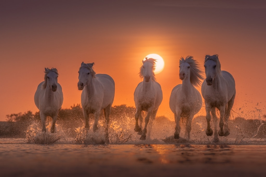
Albert Dros is a well-known photographer; he is famous as a landscape photographer from the Netherlands. His passion for nature and landscape photography is amazing.  He is a young photographer and worked with many big brands in the world. He aims to capture places and amazing moments in the best way. He has a master's degree in multimedia and Entertainment technology, and he is using his knowledge and talent very well. Albert Dros captured beautiful pictures of wild white horses for his series titled The White angels of Camargue. The name is used for the breed of the horse, the Camargue, which history is old and famous in the region of Southern France. It is also called one of the oldest breeds in the World, today they are semi-wild living in the area’s marsh.

 Dros has been conscious of these horses for many years. Horses are the best companions of humans ever and the attraction for the photographer is also an incredible subject. In this blog, we are focusing on the photography of Albert Dros. Another photographer Danial Kordon has been organizing tours for a long time. Dros and a photographer’s group spend five days taking pictures of the creatures and their guardians, they look after them.

Dros explained the relationship of horses with their guardians and said that they have a special connection with guardians. After observing the behavior of the guardians, Dros’s opinion was very good. According to him. They are very calm and kind.

The way Dros take pictures is impressive and due to his method, he is famous among photographers. The photos of Dros and its features are action shots of these horses with amazing moments with their protectors. To get a variety of photos, he guided horses in some directions. After communicating with the guardian during the photography and asking them to run through the water with the beautiful view of the sun behind them, they tried to capture different poses. There are also photographs of different locations and habitats of horses and guardians.


There is something special about the Camargue’s white horses.  Their characters, elegance, and qualities are very special. The beauty of horses can be seen in these adorable and magnificent photos that are taken by this talented photographer. Dros provided a chance to see all his views of the beauty of these horses and admire both flora and fauna. The series that came out is really impressive. He said that I tried to capture every moment of these horses like while running, standing and sitting, etc., and also discussed their close-up details. The amazing part of his photography was the running of the horses in water and the combination of sand with splashing water and dust. These are the positions where you can see the picture and its movement.

The one thing that people did not notice in these pictures nut that is present there are mosquitoes. Mostly they are present in forests and swamps, there were 10000s in quantity. According to Dros, no spray worked there and they seemed to love my blood. He shared his struggle while taking photos and said that “After the first evening of photographing, I already had more than 50 bites. Luckily, they were not extremely itchy and I took them for granted. Because the shots and experience were worth it!”


Albert Dros: Website | Facebook | Instagram | YouTube


Santa Cruz del: Most Crowded Island

Santa Cruz del: Most Crowded Island

Santa Cruz del Island is a small coral island, and one of the tiniest, in the land of San Bernardo off the coast of Colombia. The size of the island is 2.4 acres, and 1200 people are living there. The population of Santa Cruz Island density is more than four times that of Manhattan.

On this Island, there is no Manhattan, and no sewage system or running water. People can get electricity for just five hours a day through generators, and the Colombian navy dropped off fresh water once every three weeks. So there is a question why do people live on this Island?A group of fishermen, who were legends have this place about 50 km away from this Island, in the coastal town of Baru, were looking for new waters to fish when they fell upon this small island, and they were sitting where low water is. Due to late return, people decided to set up camp on this island for a late night stay, and that was the time when they discovered that island, the uniqueness of this land was there is no mosquitoes there. People stayed there in very good weather and that night they slept in peace.

Today, we see the area of this island consists of 90 houses, one restaurant, a school, two shops, a disco and a packed area that’s the size is a soccer field and a half. This area is a densely populated island on earth. There is so limited space that many structures expand onto the water, by using artificial means. There is the possibility of some houses with multi-story but most of them are single stories. The unoccupied space is a courtyard that is about half of the size of a tennis court, its structure is amazing which is with high tides underwater and it remains there frequently.

Most of the islanders are either staff members who are working at resorts and hotels or fishermen on nearby islands. There is only the occupation of the people who were living there, was fishing for a very long time. But over time, in current years, people of that area were searching for some other work. Now their dependence on tourism has increased and the position of their economy is improving. There is another island that is situated nearby Mucura, which has a high-end resort and offers snorkeling or diving, fishing to tourists, and many other facilities. The people of Santa Cruz work there. Others sell many things such as crafts, shells, and local food to the tourist.

Despite the difficult life on the island that is faced by the locals, the environment of the island is peaceful and comfortable. There is no crime or violence, so there is no concept of the locked door on this island, and according to the children who are living there is that the place can be described as better disciplined and docile by their school teacher.

The electricity is provided by a generator that is turned on from seven to eleven in the evening, and provided power on the island. There is a specific time for soap operas on television. People will use their resources to purchase gasoline during football games so that they could on the generator to watch the game on Television.

The driving instructor of 66 years old, Juvenal Julio, and the other person who is the great-grandson of one of the famous founders of the island, said Santa Cruz del Island is a paradise. According to him “I will live the rest of my days here. It’s a glorious life

Photo credit: Hotel Punta Faro

Photo credit: unknown

Photo credit: Juan Reyes/Panoramio

Sources: Toronto Star / CNTraveller / Colombia Reports / Frontrunner Magazine

Gas Bag Vehicles

Gas Bag Vehicles
Wood gas cars were not only the solution to the short supply of Gasoline in World war I and II. The expense of these vehicles was less because it is made from coal, not oil. It was a gas that is rich in hydrogen and carbon monoxide. It is the generator of wood gas that is called a gasifier that is used in a wood gas vehicle. Vehicles run with natural gas and fuel were very popular in the early 1990s in many parts of Europe and America. Natural gas was not taken from petroleum which becomes very dangerous during the two world wars. Two other unusual sources are wood and coal. Coal and wood both can get from burning coal wood. 
Gas Bag Vehicles

This gas is made by burning wood put through a pipe directly to the vehicles. This process was very popular during World War two because of the huge gasoline shortage. But the process of making coal gas is very complicated and it is carried out in big stoves in plant pyrolitic distillation. There are no small-scale gasification units that can be put along in trailers. But in the case of gas vehicles carry the gas in many bags and placed it on the top of vehicles. These bags are called shortage bags that are made of silk and some other fabrics. It is the best way to save it from leakages. Compressed gas in metal tanks could not use due to carbon monoxide, which is part of coal gas, fractures quickly when it is compressed. But on the other hand, some flammable components, such as hydrogen, are very difficult to contain under pressure and it leaks away from steel tanks when compressed. So if we think about fabric bags that were very cheaper and easier to make than metal tanks. The biggest drawback is that the bags should be comically large. The energy density of coal gas is very low than that of CNG or LPJ. For the replacement of a liter of gasoline, two cubic meters of gasoline are needed. The structure of the vehicle was very unique that was fitted with a wooden type box that was locked to the top roof and strengthened the bumpers of the vehicle. The gas bag was fastened to the wooden framework. Gas bag vehicles had horrible economy because of poor aero dynamicity of the vehicles, having a huge bag on the roof, and due to the size of the bag. These bags vehicles also suffered from engine damage and loud bands. The vehicle was fitted with a wooden framework which was fastened to the roof and the reinforced bumpers of the vehicle. The gas bag was strapped to this wooden framework. The coal gas vehicles have become unused as gasoline but it was available again after World War II. Strangely, it is still in use after the 1990s, when it was used as public transportation at the cheapest rate that was developed in peacetime. 

Gas Bag Vehicles

Gas Bag Vehicles|


SOURCE:
# Gas bag vehicles, Low tech magazine
# Coal-gas Powered Vehicles, www.douglas-self.com

The First World’s Floating City of Maldives

 The First World’s Floating City of Maldives

Photo: Waterstudio.NL/Dutch Docklands

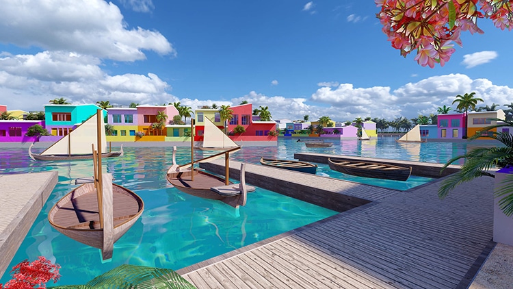
The first floating city in the world is situated in the beautiful Ireland Maldives, with the great support of the government, according to the legal framework. There are thousands of beautiful houses. It also provides the opportunity to live there and obtain a residence permit by inviting the international community to purchase a house there, live permanently and rejoice in the beauty of the Maldives, the lifestyle of Maldivians, and try the fabulous experience of living with the sea and mixing green values with the sense of place based on centuries and the experience of feeling tropical surroundings, the perfect weather, and the smooth breeze.This floating city represents the unique culture of this sailor nation. As living on the water is aligned with their history and culture, the Maldivians have a special and strong relationship with the sea. The main characteristic of the city is that is famous as a boating community due to its unique infrastructure that is for gateways and logistics, and by doing so decreasing the land-based movements to biking and walking on natural white sand roads. Only bicycle or electric noise-free scooters/buggies are allowed and cars are restricted due to such roads.The architects of the water studio named Developer Dutch Docklands have conceived a next-generation sea-level water-proof urban development, by using green technology, commercial viability, safety, and a healthy new lifestyle that will prove the backbone of future floating cities. By doing this, the citizen can rewrite their journey from climate refugees to climate innovators.It is situated just ten minutes by boat from the capital Male to the international airport, The floating city of Maldives is a flexible, dynamic city with a network that can respond to dynamic weather, its demand, and climate change. By using innovative sustainable development technologies and applying best practices of an ecological system for the protection purpose, to enhance and preserve the pristine eco-system of marine. This is a unique and adorable city of the world that is the future benchmark for the development of other projects like this around the world. It is a very unique city both upper side and underneath. The rising sea level is the result of climate change. In this world, this is normal and also happening on many islands. In islands, one of the beautiful places in the Maldives, situated in the Indian Ocean, is now facing such issues and challenges. With the partnership of Dutch Docklands, a Netherlands-based company with the government of the Maldives it built a floating city.  That is the solution to the housing problems and also a revolution while respecting the ecology of the region.The amazing architecture of the Dutch Docklands has been planning a wonderful, colorful city over the years. The ten minutes distance from the male, the capital of Maldives, will sit housing for 20,000 people. A flexible, connected and fixed grid will rest in the largest protected waters. The amazing shape of the city is like a coral structure.Restaurants, shops houses, and schools will all have the property of waterfront along the winding canals that bend through the plan of the city. The price of the house will range upward from 250,000 dollars.  It is called a luxury vacation destination for the wealthy, the project developers and the government hope that its price will be reasonable to the local citizen as well. The construction of the houses has begun and the expected residents will arrive in 2024.The best solution for the overpopulation and the solution to the flooding issues as the sea level rise, this city is the hope for floating city developments.Former President of the Maldives, Mohamed Nasheed, said in a statement, “Our adaption to climate change mustn’t destroy nature but work with it, as the Maldives Floating City proposes. In the Maldives, we cannot stop the waves, but we can rise with them.”

 The First World’s Floating City of Maldives


Photo: Waterstudio.NL/Dutch Docklands

A wonderful Pillar at the Center of the Circular City of Gor

 A wonderful Pillar at the Center of the Circular City of Gor

This minar was like a tower which is built in the middle of the Sasanian City of Gor, named Milo Sassanid Ancient Tower. That is very famous among travelers and orientalists. This structure is first found by Pascal Coste and Eugène Flandin. It was a unique tower in Iranian Architecture and is called the legend of Iranian history. That was Alexander, the part of the Persian Territory, defeating its regions and its cities, ending in the capture of the Persepolis in the year of 330 BC.

He constructed a dam in a close-by gorge, keeping the water of the river connected to the plain, where the city is located. That is fully flooding it and making a lake that stayed until the end of the 3rd century AD. After that, king Sassanid Persian tunneled to drain it and destroyed it.

 A wonderful Pillar at the Center of the Circular City of GorThe site of the ancient city of Gor with the pillar at its center. Photo: Amin malekzadeh/Wikimedia

He founded the new capital at the same place, that is called Khor Ardshir or Gor. He made it famous on a circular plan (many centuries before the well-known circular city of Baghdad) with an amazing measurement that the famous Persian writer named Ibn Bakhi wrote that it was designed with a compass.

The diameter was 1,950 meters and was covered by a protective moat 35 meters wide, which could only be avoided using four bridges that provide access to its four gates, and a wall of clay, and each part has cardinal points. The city was distributed into 20 parts by an accurate geometric system of several concentric ones and twenty radical streets.

There is another walled circle inside it, its radius was 450 meters, in which the palaces and the royal buildings were built. The current area that is landscape shows the old setup of the city. The length of the largest tower is 45 meters and its structure remains the same.

 A wonderful Pillar at the Center of the Circular City of GorPhoto: Carole Raddato/Wikimedia


It is called Terbal by Arabs, but according to Persians, they said it as Minaret or Minar like a pillar. The design of this pillar had unique in Persia and an external spiral staircase and it is not the same purpose of it, there are many hypotheses about it. If we calculated its width, it would be around 20 meters adding the destroyed stairs and the outside wall.

The Takht-e-Neshin called the fire Temple and the Minar were the only two designs in the city that are made of granite masonry. The first time a two-person explained the uniqueness of its structure in Persian architecture was a Westerner named Eugene Flandin and Pascal Coste, but another person who explained the systematic study was Ernst Herzfeld. According to him, it is like a stair tower. Before the study of Herzfeld, it is known as Takht-e-Neshin itself, for the prevention of dust contamination, there was a temple with a blessed fire placed on the top.

The opinion of some authors is that it explains the ideology of Ardacher’s state with the symbolized the divine and centralist kingship, and the use of it is very practical, then it showed its visual contact with defenses find the main access road to the plain, in the gorge of Tang-an. The tower is also used as an observation tower, while its work for the plan predicted by Ardacher for the new city and plain was achieved. The whole scheme is centered on the Minar, and the radial pattern and concentric of the city were 10 kilometers away, where traces of roads, canals, and walls have been found.

 A wonderful Pillar at the Center of the Circular City of Gor
Artistic representation of the Minar as a fire temple, drawing by Zenaide A. Ragozin (1889).


A study explained that it may have been a water tower, getting water from nearby sources flowing through the hollow core and the pipes of the minar to its dome, and going to other points in the city.

 A wonderful Pillar at the Center of the Circular City of GorPhoto: akhodadadi/Wikimedia

source  La Brújula Verde


Hector: A Horrible Thunderstorm

 Hector: A Horrible Thunderstorm

A view of Hector from Gunn Point, Northern Territory. Photo: Djambalawa/Wikimedia

In Australia, there are a lot of Irelands, in which Tiwi Irelands are one of them. These

Irelands are the part of Northern Territory. The distance of these Irelands is 80 km to the

north of Darwin and Adjoining the Timor Sea. The combined area of 8,320 square km.

Tiwi Island consists of two Islands. Melville and Bathurst. The people who are living

there are famous for their stunning artwork, passion for football, vibrant textile, and

traditional lifestyle.

A thunderstorm develops in the Tiwi Ireland from September to March every afternoon

in Northern Australia. Meteorologist refers to it as Hector due to its regularity. This

thundercloud called cumulonimbus mostly appears at 3 PM, and according to some

experts, It is so punctual alarm can be set. Another name of Hector is Hector the

Convector, this storm got this name after World War II when the mariners and pilots

used the thunderclouds for navigation purposes. Hector can access immense heights,

some 20 kilometers tall, and it can be seen from Darwin, a distance of 100 kilometers.
 Hector: A Horrible ThunderstormHector as seen from Stokes Hill Wharf in Darwin. Photo: Djambalawa/Wikimedia

The shape, size, and location of Tiwi Island make them an amazing place for the

development of Hector. According to Ben Domensino meteorologist with the

collaboration of a DTN company named Weather zone. The amazing view of the sea

from all sides of Ireland. The cold wind, which is moisture from the sea, needs to go

somewhere when they disturb. The temperature of the air becomes cool when it rises,

and the result of the rising air is water vapors condense and converts to liquid.

Shepherd said that it is common in wet weather where the sea air plays the role

of a lifting trigger, and this weather is a tropical atmosphere. The weather from

September to December is called the build-up session and Hector is commonly found

during the summer. If the temperature increases, it shifts into April. During the late dry

session (In September), winds extending their size from the subtropical ridge to the

south will defeat thunderstorm activity more than in the Northern Territory. And before

the wet session in October and November, the prominent feature of leaving Hector is

the isolated feature on the Darwin skyline. This was the point of view of Lan Shepherd,

who was the senior meteorologist at the Australian Bureau of Meteorology.


The weather of Tiwi Ireland is unexpected and its tropical atmosphere is always

prepared for the formation of a thunderstorm during the wet season when the breeze of

the sea converges and provides the trigger, said, Shepherd.

Hector is also happening during the warm months which is called build-up season from

September to December. Hector is also common in the rainy season from January to

March. Sometimes Hector appears in April if the temperature of the wind is warm

enough.

The one condition when Hector does not appear is when there is a continuous

westerly monsoonal flow.

The cloudy weather and the westerly winds connected with a serious

monsoon tends to suppress sea breezes on all the Irelands, decreasing the

likelihood of Hector forming regularly. According to Shepherd, “An active

monsoon also generates regular showers and thunderstorms which move

rapidly across the islands from west to east in the relatively cool maritime

airstream."

The best time or condition for the hector to occur is when the sky is clear with

a very light wind, this is not only suitable for strong solar heating, and also the

source of daytime sea breezes. In the months of winter from May to August.

There is no chance of Hector and it lowers the strength of the sea breezes.
Source: CNN